[title subtitle=”words: Jim Warnock
Images: Eric Scowden and Jim Warnock”][/title]
Waterfalls put many into a reflective state. Still others, tired from the pressures of modern life, simply enjoy the relaxing sights and sounds waterfalls offer. Either way, they seem to work their magic on just about everybody, and Arkansas has some beauties.
Hiking distances featured here are no more than a two-mile round trip, but you’ll probably do some climbing. You can view three of these waterfalls from your car, and all are kid friendly. We’ve listed them by distance from Fort Smith, ranging from twenty minutes to two hours. In Arkansas, all waterfalls are seasonal, and many only flow during wet times of year. Wear shoes that grip slippery rock and plan on getting muddy. Pack your camera, water, and some snacks and hit the road!
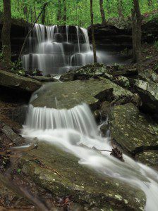
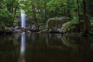
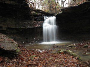 McWater Falls at Lake Alma
GPS at the trailhead: N35° 29.818’ W94° 13.073’
Driving directions: Take the twenty-minute drive north on I-49 then east on I-40. Take Exit 13 and drive north to the first traffic light. Turn right onto Collum Lane East. Drive 0.2 mile and then left on Mountain Grove Road. Drive north on Mountain Grove Road for 0.3 mile and take a left just past the two green water tanks. Drive down to the picnic area parking. The Lake Alma Trailhead is at the opening in the parking guardrail.
Walking directions: Follow the round yellow trail markers (called blazes). Walk north with Lake Alma to your left for 0.5 mile to the stone McWater Falls sign. Turn right and walk one-tenth of a mile following orange blazes to the waterfall, which was named for Harry McWater, the father of the Lake Alma Trail.
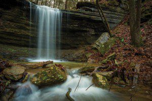
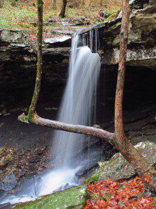 Crack-in-the-Rock Falls
GPS at the trailhead: N35° 29.376’ W94° 24.570’
Driving directions: From I-40 in Van Buren, take Exit 5 and drive north on AR 59 for 1 mile then turn left onto Old Uniontown Road and go 1.6 miles. Turn left onto Pine Hollow Road and drive 2 miles. Turn left onto Gelly Drive and drive 0.8 mile to the trailhead.
Walking directions: Take Crack-in-the-Rock Trail and follow the blue blazes. Cross under a power line at 0.3 mile and look for the Crack-in-the-Rock Loop to your right. Take the left side of the loop that leads you on the right side of the creek following it upstream. At 0.5 mile you’ll arrive at a junction where a trail leads to the left and down to creek level. Pass some bus-sized boulders and quickly come to a drain where you’ll scramble up to the right, arriving at the wet season Crack-in-the-Rock Falls at 0.6 mile. Backtrack the way you came to complete this 1.2-mile hike.
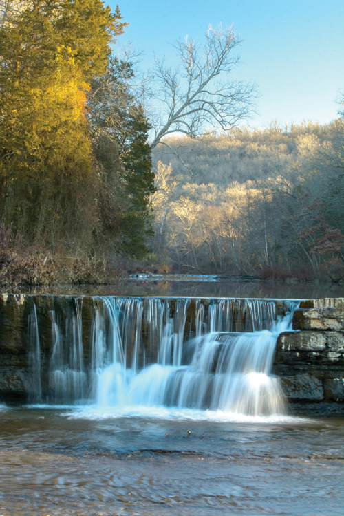 Natural Dam
GPS at the waterfall: N35° 38.989’ W94° 23.862’
Driving directions: From I-40, take Exit 5 then turn left onto AR 59 North/Fayetteville Road. Continue north for 14.4 miles. Turn left onto Natural Dam Road and watch for the waterfall on the right (north) side of the road. You may view this waterfall from your car or walk around Natural Dam Falls and upstream alongside Mountain Fork Creek.
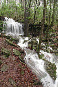
 Shepherd Springs Falls
GPS at the trailhead: N35° 41.735’ W94° 07.108’
Driving directions: From I-49, take Exit 29 at Mountainburg and go east on AR 282 for 1.8 miles to US 71, and then drive north on US 71 for 7.5 miles to Shepherd Springs Road. Turn east on Shepherd Springs Road and go 2 miles to the park.
Walking directions: Begin on the left side of the visitor center. You’ll walk the first mile of the 180-mile Ozark Highlands Trail to reach Shepherd Springs Falls. Watch for white blazes that mark the Ozark Highlands Trail. At 0.9 mile, you’ll arrive at this wet season waterfall and cascade. Backtrack the way you came.
 Devil’s Den Twin Falls
GPS at the trailhead: N35° 46.802’ W94° 14.961’
Driving directions: From I-49, take the Winslow Exit 45 and turn left on AR 74. From the turnoff, it’s 6.8 miles to the Devil’s Den Trailhead. At 4.5 miles, you’ll pass the Devil’s Den State Park sign on the right. Continue down the steep switchbacks until you reach the 6.8 miles point and watch for the parking area on the left. The trailhead is on the right side of AR 74. Watch for traffic when you cross the highway to enter the trail.
Walking directions: Begin at the Devil’s Den Trail located next to the visitor center. Hike past Devil’s Den Cave and Devil’s Icebox before arriving at Twin Falls at 0.6-mile. Backtrack the way you came or continue on the loop if you’ve picked up a map from the visitor center.
 Highway 23 Pig Trail Falls
GPS at the waterfall: N35° 38.757’ W93° 50.365’
Driving directions: From I-40 in Ozark, take Exit 35 and turn left onto AR 23 North. Drive 9.9 miles and look for the pull-off on the right side of the road just before a sharp right curve. The waterfall is on the left (west) side of the highway. Be sure you have a designated driver to avoid running off the road while gawking at the falls.
 Turner Bend Falls
GPS at the waterfall: N35° 40.034’ W93° 49.683’
Driving directions: From I-40 in Ozark, take Exit 35 and take AR 23 North. Drive 11.7 miles to Turner Bend Store. The waterfall is on the right side of the highway just south of the store. Be sure to stop in for a piled-high deli sandwich. Tell them to “throw the garden on it” and you’re in for a crunchy treat! They also serve up current trail and river info.
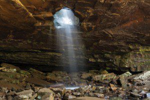 Glory Hole Falls
GPS at the trailhead: N35° 49.702’ W93° 23.427’
Driving directions: From the town of Ponca, drive southeast on AR 43 South for 4.8 miles. Continue onto AR 21 South and drive 11.2 miles. Take a slight right onto AR 16 West/AR 21 South and drive for 2.3 miles. Just before arriving at the trailhead, the road makes a sweeping turn to the left and Cassville Church is on the right. Watch on the left (south) side of the road for a small parking area and a small white sign that says Glory Hole. If you pass a barn on your right with a large ‘E’, you’ve gone too far. The total distance from Ponca to the Glory Hole Trailhead is about 18 miles.
Walking directions: Take the trail on the south side of AR 16. Follow an old roadbed for a short distance before heading downhill and across a seasonal creek. Follow the stream down to where the water disappears into a hole in an overhanging ledge. Backtrack to the highway to complete this 2-mile hike. Visit this waterfall early in the morning to avoid crowds.
 Cedar Falls
GPS at the trailhead: N35° 07.005’ W92° 56.334’
Driving directions: To get to Petit Jean State Park from I-40, take Exit 108 for AR 9 South toward Morrilton. After 7.5 miles, turn right onto AR 154 West and drive 11 miles to Petit Jean State Park and 1.5 miles past the visitor center to Mather Lodge. Cedar Falls Trailhead is at the overlook behind the Mather Lodge breezeway.
Walking directions: Follow the 2-mile out-and-back Cedar Falls Trail down switchbacks and across Cedar Creek. Turn right after the creek and follow it upstream to Cedar Falls. When the water is flowing, Cedar Falls is spectacular. The trail is a visual feast every step of the way.
If you visit some of the waterfalls shared here and want more, pick up a copy of Tim Ernst’s Arkansas Waterfalls Guidebook. Some locations are challenging, requiring GPS and some serious scrambling, but there are waterfalls for hikers of all levels of fitness and expertise.
For more on photographer Eric Scowden, visit Facebook.com/EricDScowdenPhotography/Jim Warnock’s book, Five-Star Trails: The Ozarks, will be available in October. OzarkMountainHiker.com