[title subtitle=”WORDS and IMAGES Jim Warnock, black and white images, Reese Kennedy”][/title]
At five years old, I approached my mother’s older brother. “Uncle Reese, would you draw me a Texas Longhorn?” He was a soft-spoken art teacher and politely put off my request. Finally, after two days of repeated appeals, I said, “Uncle Reese, CAN you draw a Texas Longhorn?”
Reese Kennedy, who would later become the first president of the Southwest Watercolor Society and art professor at Stephen F. Austin University, led me to his studio. I watched with wide eyes as his paint-splotched fingers made graceful ink marks with a surgeon’s precision. Faint outlines of eyes and horns took shape. A slight smile formed behind his beard as he scraped the paper with colored chalk. In a quiet baritone voice, he said, “There, your very own Texas Longhorn.” It was signed “Drawn for Jim Warnock Thanksgiving 1960.”
After Reese’s death, I learned that he once drove Scenic Highway 7, making repeated stops to paint or take photos to paint from later. Passers by must have felt envious of that free-spirited artist next to the road watercolor palette in hand. Since I shared their envy, I decided to retrace his path.
Over the years, I’ve hiked many trails that intersected Highway 7 but thought of the road in practical terms as just a way of getting to the trails. For this trip, I would attempt to see not only with Uncle Reese’s eyes, but also through the lens of my life experiences, stopping, not to paint, but to capture scenes with my camera. What follows are only a few of those stops.
We began at the Louisiana border, south of my hometown, El Dorado. My wife Becca served as my navigator to keep me on track in case I became engrossed in the scenery. Highway 7 isn’t considered “scenic” until Hot Springs, but we saw beauty and history in the lowlands, too!
El Dorado has one of Arkansas’ best examples of a revitalized downtown. Over the years, I watched its decline and rebirth that now includes gourmet restaurants, a vibrant business community, and the possibility of catching a concert at the Murphy Arts District.
North of Camden, we discovered tangible evidence that we were indeed tracing Uncle Reese’s footsteps. Reese’s daughter sent several photos that he took on his trip. From his faded slides, I learned that the wooden bridge where Highway 7 dips beneath the Union Pacific Railroad fascinated both of us. Standing next to the tracks that disappeared into the distance, I caught the faint smell of creosote in the still air.
Walking a short distance from the rails, I found myself in a ghostly green world on the edge of Newman Slough. Staring into the distance, I thought of our state’s geographical diversity. Standing next to this swamp, I was now viewing a landform typical of the West Gulf Coastal Plains. Our trip up Highway 7 would take us through three more regions before its end.
The character of the road changes as it travels north through Arkadelphia and Hot Springs. Hills and curves become more pronounced. Motorcyclists love these winding sections that snake through our second geographical region, the Ouachita Mountains.
North of Hot Springs, Highway 7 crosses the 223-mile Ouachita Trail (OT). As I thru-hiked the OT in 2018, I walked the four-mile Hunt’s Loop that intersects with the Ouachita Trail here, winding south to Iron Springs Recreation Area. Reese stopped in this same spot and watched children picking through colorful pebbles below the clear water. You can easily stop your car to view this beautiful, clear stream.
As we entered the River Valley, our third geographical region, we passed within a few miles of Petit Jean State Park, where I learned to love hiking as a child. Powerful water eroded surrounding land to leave Petit Jean Mountain standing in the valley. A wealth of trails and scenery await the traveler who decides to take a break here or spend a few nights. A two-mile round-trip hike from Mather Lodge leads to Cedar Falls, one of Arkansas’ most visited waterfalls. I have a favorite boulder there for listening to the roar.
After crossing the Arkansas River at Russellville, we entered the Ozark Mountains, our fourth and final geographical region covered by Highway 7. We came to the intersection of Highway 16. Five short miles to the east, Pedestal Rocks Scenic Area transported us to a scene from another planet with towering rocks and deep crevices.
Jasper, one of my favorite Arkansas towns, is a great jumping-off point for Buffalo River floating and hiking. After hiking Roundtop Mountain, we explored the edge of the Buffalo River where Highway 7 passes over it on a bridge built in 1931. A short drive east of Highway 7 took us to the Low Gap Cafe, an unlikely location for gourmet meals. Definitely worth a few extra miles!
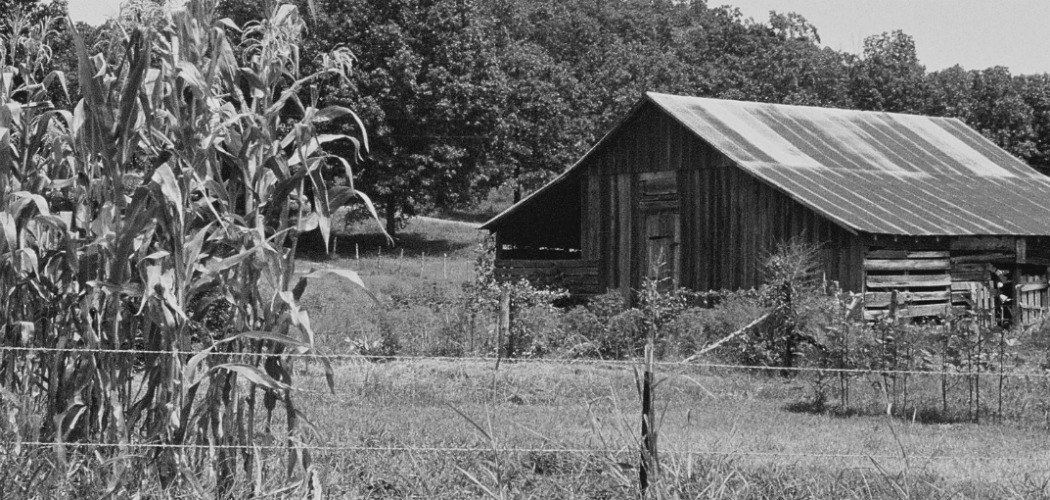
After passing through Harrison, we came to the Lead Hill area. Becca said, “That looks like a Reese Kennedy painting.” I pulled off the road and walked back to the barn she’d seen. Reese would have liked how the cedar post fence added perspective and distance to the scene.
Only a few miles farther led us to Bull Shoals Lake and the northern terminus of Highway 7. As I stared out over the water, I thought of early influences in my life. Uncle Reese couldn’t have anticipated the impact he was making on his persistent five-year-old nephew. I’m thankful for a childhood filled with stories of curious and caring adults. Isn’t this the reason we snap the camera shutter, paint the picture, or write the words? What a privilege it is to tell our children where we’ve been and the beauty we found there!
About Jim
My name is Jim Warnock (trail name – Tater). I explore the Ozarks by trail and like to carry a camera. On my blog, ozarkmountainhiker.com, I share pictures and thoughts related to wherever the trails may lead. You’ll also find a few thoughts from my dog, Hiker. Our goal is to inspire you to lace up your hiking shoes and head into the woods. My trail guide, Five-Star Trails: The Ozarks, is a good tool for exploring the Ozarks. Follow Jim, me, on Twitter: @jimwarnock and Instagram: @ozarkmountainhiker


