[title subtitle=”WORDS and IMAGES Dwain Hebda”][/title]
A first-timer rides The Pig Trail
There are a few journeys everyone should take in their life. The journey of self-discovery, the path of righteousness and the road less traveled are now and again good for the soul and improve us as human beings. Or, if you live in Arkansas, just take The Pig Trail, a ride that rolls all three of those into one.
Like a lot of people in this state, I had heard of the legendary route, even wrote about it from time to time. But in nearly twenty years living in Arkansas, time and fate had never aligned sufficiently for me to experience it for myself. Until now.
I want to say up front that I could have picked a better weather day as the morning of my departure from Little Rock dawned gray and rainy with a low cloud ceiling. I also want to say the irrefutable law of the deadline had come into play by this point and I was to take what Mother Nature was dishing out and like it. Hell hath no fury like a woman scorned, unless it’s an editor waiting for their copy.
The Pig Trail is well-known to Arkansans of a certain age, because in the years preceding completion of I-40 in 1975 and the northern segment of Interstate 49 in 1999 (better known as the John Paul Hammerschmidt Highway), Arkansas Highway 23 was an alternate route for getting between Little Rock and Fayetteville.
With each modern highway that has come along since then, The Pig Trail became less and less the preferred route for football fans, college students and other non-local traffic that it once was. Yet it remains no less a coveted bucket-list highway. USA Today once ranked it second on the list of best motorcycle rides in the U.S. and seeing the photos of it in its autumnal Technicolor splendor, it’s not hard to see why.
The whole of Highway 23 runs more than one hundred twenty miles from about Ozark through Eureka Springs and on to the Missouri border, and while some people call the entire stretch The Pig Trail, technically that’s not true. Nor is it precisely accurate to call the combination route of Highway 23 and Arkansas Highway 16 west to Fayetteville The Pig Trail, even though that’s the route of old for the Razorback faithful.
The Pig Trail Scenic Byway, as its formal name reads, only covers about the first twenty miles from I-40 north, terminating at Brashears. Twenty miles may not sound like a lot, but I’m here to tell you it will give you everything you can handle and more.
The rain had picked up by the time I hit my exit and nosed the truck north. I’m not ashamed to admit I noticed my pulse had quickened for what was to come, not unlike the moments sitting in a roller coaster when the yoke comes down and you’re locked in. A wry grin tickled the corner of my mouth as I noticed at the exit a wrecker service, a liquor store and a truck stop advertising clean bathrooms. I’d wager every Pig Trail neophyte identifies with one of those clienteles before their drive is done.
I reset my trip odometer just to keep tabs on where I was, aimed at Mulberry Mountain and at three tenths of a mile, the first road sign bearing the telltale squiggle appeared. It was not the most extreme turn of the trip, but we were just getting started. Checking my rearview, I saw I was alone on the highway, the truck stop shrinking from view like an old duffer who waves after you with a cackle. From here on out, it’s just man, machine, mountain, and madness.
For those who know our state, the first stretch mirrors routes around Mountain Home and Jasper, gentler even. Large pastures spread out unexpectedly around corners as herds of cattle and the occasional horses graze in the meadow. Domiciles run the gamut from hillbilly hoarder deluxe to splendid retirement acreages perched on high ground behind iron gates and long graveled drives.
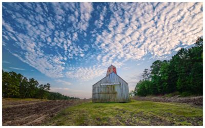
Here and there, an ancient barn stares down your approach, blank-faced for having seen thousands before you and destined to see thousands more after. Fewer still were the country churches, brick-clad and crowned with white steeples pointing the way home.
And everywhere you look, you see the mountain, anchoring the sky like a tent stake. At first, the hulking giant felt at arm’s length as if warily keeping its distance, sizing you up. Then before you know it, you’re gaining altitude, ears popping, thick stands of forest trees blocking out the valley vista while on the other side, pop-up waterfalls gurgled and splashed the day’s rainfall over the face of granite.
One-third of the way in, the trees stretched across the roadway towards each other, in places forming a tunnel of lime, kelly, emerald and moss green, the palette uninterrupted save for the yellow diamonds of steel announcing one after the other contorted curves and turns.
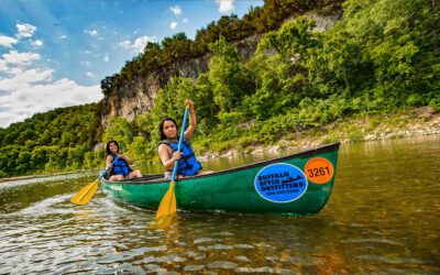
Nature is so on top of you here that the manmade actually takes you by surprise. So it was that I came around a bend and into view of the famous Mulberry River Outfitters, known to most as the Turner Bend Store, a combination grocery, deli and souvenir stand that’s the gateway to the cabins, canoes and various flotilla that is its stock and trade.
Inside, the menagerie includes everything; kayak paddles to beer, t-shirts to jerky. Faded newspaper and magazine write-ups line the walls and music plays in time with the rain on the porch. Here and there a local pulls up to grab a bag of chips or the phone jangles with another person asking about water levels. But this being a weekday, what they were doing most of was bracing for the weekend. Ample rain and warmer weather have made the nearby Mulberry River wilder than usual and whitewater enthusiasts have been arriving by the score for a month. I hung around long enough to get my land legs back, then crossed the old iron bridge and drove on.
It was as if The Pig Trail took umbrage that I didn’t buy a Coke, look at the time and turn for home from the friendly confines of the Turner Bend Store parking lot. For the next chunk of the way, the rain fell harder, the sky was darker, and the road got three classes hairier. What I didn’t know was Northwest Arkansas was under an open faucet causing major flooding to the north. Though not that bad, there was still plenty of rain coming down on top of me, with the flow from the rocks streaming across the pavement in two places and plenty of debris across several others that told me I’d missed some real danger by mere minutes.
The higher you go here, the slower you drive, and I was knocking on the sky. What started around fifty miles per hour at the truck stop would eventually bottom out at a double fishhook in the road taken at but ten miles per hour. There’s no cheating on that number, either; on the rain-soaked surface I’d drawn that day The Pig Trail was like driving on an eel.
In addition, I was starting to meet oncoming traffic, another sign that Mother Nature has a sick sense of humor. I can say, however, that unlike other parts of the state where drivers’ idiocy and distraction is on ready, text-tapping display, the locals here know The Pig Trail is nothing to mess around with. And while I can’t imagine anyone dumb enough to check their Instagram behind the wheel up here anyway, cellphone strength weeds out those who would try. Throughout my adventure, I never got so much as a smoke signal.
Roughly three-quarters of the way to done, I pulled into the Mulberry Mountain Lodging and Events compound. Built out of an old blueberry farm, the small general store sits inside the former barn where the harvested fruit was once processed. I chatted up the man in charge, whose family owns and runs the place, and discovered that with the exception of weddings and events, the events of last year had done little to slow the stampede of people that trek here to breathe the mountain air and get back into balance with the natural world.
Looking out the front window at the massive hidden valley, it was clear social distancing wasn’t a problem up here. Gathering up a resuscitating iced tea, I scratched the company mascot Rascal the spaniel behind one velvety ear and moved on.
The Pig Trail had one more sucker punch up its sleeve. With but a few miles to go, I came around a corner into a pocket of clear road and sank into a suffocating fog that whited out everything in front of me. For a moment I felt suspended between heaven and earth, churning clouds under my wheels. As the dark outlines of warlock trees took shape, the velour mist dissipated, and the road slid down the green gullet of trees.
Then, before I could process what had just happened, it was as if blackout curtains had dropped and the landscape became open, flat, and calm. Twenty miles on the dot. Time to go home.
The return trip held few surprises (although coming back through the fog to meet two moving vans coming the other way got me a lot closer to Jesus). You never want to get too comfortable on The Pig Trail, of course, but there’s something to be said for letting the color back into your knuckles and taking more things in. Before I knew it, the truck stop rolled into view and I was back on the Interstate, headed for home. I couldn’t help but notice how tame and safe and boring it felt.
I’d just given forty miles and about five years off my life to the most iconic highway in the most breathtaking place in the world. I’d pulled over to see albino waterfalls, listened to what the mountain was trying to tell me, found the joy in joyride. It was too much to know in one drive, so I promised myself I’d be back, enriched by the adventure I’d just had and compelled by what would always be here, waiting, ready for more.
Maps and More: arkansas.com/ozark/tours-experiences/pig-trail-scenic-byway
Turner Bend Store
Ozark, AR
turnerbend.com
479.667.3641
Mulberry Mountain Lodging and Events
Ozark, AR
mulberrymountainlodge.com
479.667.1919